After 7 years of testing, development, analysis, and evaluation, India has announced its autonomous satellite navigation system. This is a huge achievement and with the successful launch of NavIC, India has joined the elite club of members who are technically advanced. ISRO has helped India launch its very first regional satellite navigation system.
The best part of this system is that your smartphones, fitness bands, vehicles, drones, and smart devices will replace the GPS system and adapt to this new satellite navigation system NavIC.
NavIC stands for Navigation with Indian Constellation. This name is getting popular among the Indian public as a successful alternative for GPS. The real name of this project is Indian Regional Navigation Satellite System (IRNSS). You may have got a brief idea now, but still, let us discuss this in detail.
Engineered by the Indian Space Research Organization (ISRO), NavIC is a satellite navigation system built for India. Messaging, real-time positioning, accurate real-time positioning are some of the features this navigation system offers. It is a unique alternative to GPS.
GPS is owned and run by the US, while NavIC is owned and run by India and it covers India and some neighboring countries.
This satellite navigation system is designed to reduce the over-reliance and dependence on US technologies. India has joined the list of elite members owning their own navigation systems including Russia, China, and Europe. In the coming years, ISRO is planning to increase the coverage area around the planet.
NavIC has a total of 7 satellites that are located at an altitude of 35 kilometers from the Earth’s surface. Each one of these satellites is aligned to India and have a direct line of sight. These satellites are handled by ISRO and are rotated at a fixed velocity.
Out of the 7 satellites, 3 revolve in the geostationary orbit of the Earth and are in direct line of sight with the ground station of India.
Every satellite has three Rubidium atomic clocks. These clocks are programmed to calculate:
- Your distance
- Your time
- Your precise position from the Earth
This calculation is done using radio frequencies.
NavIC is a unique satellite navigation system designed, managed and handled by ISRO. There are some features that make this navigation system even more advanced. Let’s have a look at these features:
#1. Coverage
The coverage of this navigation system is not that huge but it covers entire India and some neighboring countries including Pakistan, Bangladesh, Sri Lanka and some parts of China.
NavIC covers entire India and 1500 kilometers from the borders as well. ISRO is planning to extend the coverage on a global scale as it has promised to launch 4 more satellites.
#2. Satellites
NavIC has a total of 7 satellites and India has kept two additional stand-by ground satellites. NavIC uses the L5 frequency to locate and track devices such as smartphones, tablets, iPads, and automobiles. This service is known as the Standard Positioning System.
Furthermore, NavIC uses S-band frequency. This is solely for military use and is encrypted. This service is called Restricted Service. NavIC is following the standard protocols used by some major space agencies.
#3. Accuracy
If we compare GPS with NavIC, the latter is a clear winner because of more satellites covering a smaller portion of Earth.
In comparison to the 31 satellites orbiting around the Earth, GPS cannot easily cover the dense areas due to the latching issues.
While on the other hand, NavIC has 7 satellites and is aligned to the line of sight of India. The lesser number of satellites of NavIC makes it easy to cover entire India and a few neighbouring countries.
Out of the several countries, only 5 have their own navigation systems. India has bagged a place in the elite club for having its own satellite navigation system and this is a proud moment for all the Indians, especially for the employees of ISRO.
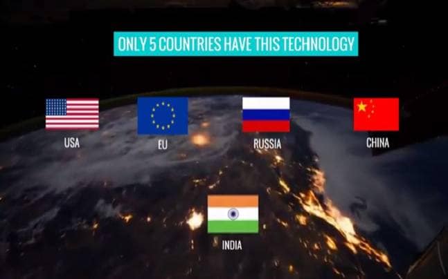
India: NavIC (Navigation with Indian Constellation)
USA: GPS (Global Positioning System)
Russia: GLONASS (GLOBAL NAVIGATION SYSTEM)
Europe: Galileo (Global Navigation System)
China: Beidou (Regional Navigation System)
After 7 years of hard work, deep analysis, and experimentation, India has successfully launched this regional navigation system. For now, this system covers entire India and some neighbouring countries including China, Pakistan, Bangladesh, and Sri Lanka. ISRO has plans to further expand the coverage area on a global scale.
This is a huge achievement for India on an international level.
“This is a great gift to our people from our scientists. This successful launch which is powered by our own technology will determine our own paths.”, said Narendra Modi.
This region navigational system is beneficial for all but mostly these are the class of people who will be greatly benefited by the system:
#1. Fishermen and Sailors
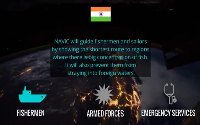
NavIC will greatly guide our fishermen and sailors to portions where there is a high concentration of fish.
It will also assist them in their course and will keep them from drifting into unknown and foreign waters.
#2. Defense
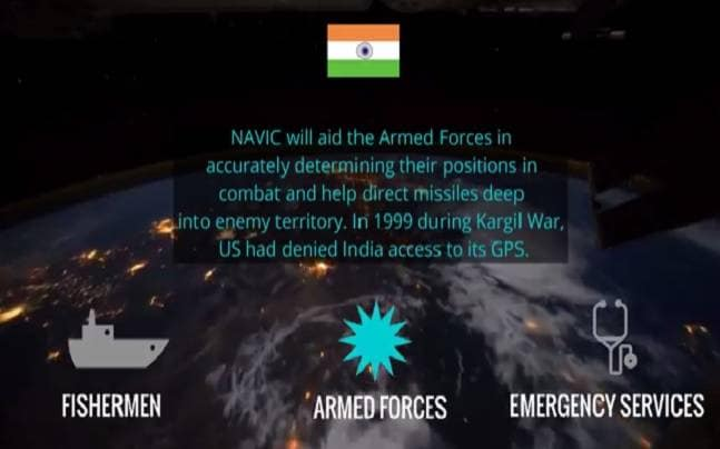
With the S-band frequency, armed forces will be greatly benefited. The satellite system will guide the Indian Navy and Army in determining their positions with even greater accuracy.
India’s line of defense has gotten stronger and this will open doors to new strategic plans that will enhance the national security.
#3. Aid and Relief Services
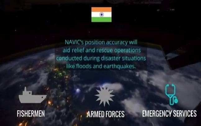
The aid and relief services will be able to easily track down situations and affected areas where people need help.
This navigation system will also guide relief operations conducted during emergency situations where areas are affected due to natural disasters.
Final Verdict
So this is all about the NavIC. It is completely different from the present GPS navigation system. ISRO is doing a great job in helping India move toward its quest of achieving self-dependency.
We expect an increase in the number of smartphones, fitness bands, smartwatches that support NavIC. Various chipset manufacturers are collaborating to make NavIC fully support their products.
Image Source: India Today